Evacuation Timing
How Early Do You Have to Leave With Pets? Working the Leave-By Clock Backwards
By EmergencyPetPrep Editorial · Updated
Short answer: Subtract your county's published clearance time and your own timed household load time from the hour the hazard reaches you; that leave-by hour is usually well before the evacuation order. For US hurricanes, the National Weather Service issues a Watch 48 hours and a Warning 36 hours before tropical-storm-force winds, but these are forecast lead times, not departure instructions. Treat the watch as the point when animals, carriers and documents are already staged.
Researched and written with AI assistance from the published sources listed at the end of this page. We are not veterinarians, no veterinarian has reviewed this page, and we do not test products by hand, so check those sources and talk to your own vet about your animal. How we work →
Read this first
Some pet emergencies outrun any checklist. If an animal is collapsing, struggling to breathe, or was exposed to something toxic, stop reading and call your veterinarian or the nearest emergency animal hospital now. When officials order an evacuation, go; nothing on this page is worth delaying your own exit. This article is spec-and-evidence analysis of published guidance, not veterinary care for your specific animal. Where your vet's instructions or an official order differ from anything here, they win.
Key takeaways
- Leave-by time is a subtraction: the hour the hazard arrives, minus your jurisdiction's published clearance time for your zone, minus your household's time to catch, crate, load and drive. Clearance time is published locally; you measure the household term with a drill.
- For U.S. tropical cyclones, the National Weather Service issues a Hurricane Watch 48 hours and a Warning 36 hours before anticipated tropical-storm-force winds, because preparing may not be safe once winds reach that strength. These are forecast lead times, not a departure instruction.
- Clearance time sizes your window, and it is zone specific. South Carolina's Annex C (May 2026) models Central Region Zones A through F at 59.2 hours with no lane reversal and 54.8 with the I-26 reversal; Zone A alone models at 11.4 hours.
- Support operations stop before the storm. South Carolina's fueling annex ends priority fueling no later than 4 hours before tropical-storm-force winds, and state traffic personnel demobilize in the H-4 to H-0 window. Contraflow is a state capacity tool, not extra minutes for you.
- Some hazards give no lead time. A local tsunami can arrive within minutes, an Extreme Wind Warning means eyewall winds within an hour, and the Camp Fire turned 25-minute routes into hours. For those, the leave-by decision is made in advance by pre-staging.
Take the hour the hazard reaches you, subtract the clearance time your jurisdiction publishes for your zone, then subtract the time your household needs to catch, crate, load and drive. That is your leave-by time, and it usually falls well before the evacuation order for your zone. Two of the three terms are published by agencies. The third is yours to measure with a timed drill.
The two halves fail differently. If you get the published window wrong, you leave into roads that have already closed behind you. If you get your own load time wrong, you leave on time and arrive at the driveway with a cat still under the bed.
The Equation
Leave-by time = (forecast arrival of the hazard) − (published clearance time for your zone) − (your measured household load time) − (a margin for the cutoffs that close early)
Nothing here is a national rule, because the middle terms are not national. Clearance times are county-and-zone specific. Contraflow rules belong to the state DOT that operates the road. Shelter opening windows belong to the state and county mass-care plan. The only national inputs are the National Weather Service alert lead times, and they describe when a forecast product is issued, not when your household should be moving.
What the National Weather Service Publishes
For tropical cyclones, NWS publishes these lead times:
| Product | What NWS says it means | Stated lead time |
|---|---|---|
| Hurricane Watch | Hurricane conditions (sustained winds of 74 mph or greater) are possible within your area | NHC issues hurricane watches 48 hours before it anticipates tropical storm-force winds |
| Hurricane Warning | Hurricane conditions (sustained winds of 74 mph or greater) are expected somewhere in the specified area | NHC issues a hurricane warning 36 hours in advance of tropical storm-force winds, to give time to complete preparations |
| Storm Surge Watch | Possibility of life-threatening inundation from rising water moving inland from the shoreline | Generally within 48 hours |
| Storm Surge Warning | Danger of life-threatening inundation from rising water moving inland from the shoreline | Generally within 36 hours |
| Extreme Wind Warning | Extreme sustained winds of a major hurricane (115 mph or greater), usually the eyewall, expected to begin within an hour | Within an hour |
Source: NOAA/National Weather Service, Hurricane and Tropical Storm Watches, Warnings, Advisories and Outlooks. Figures as of August 5, 2026.
The reason for those hours is the most useful sentence on the subject for anyone loading animals. NWS says it issues watches 48 hours ahead because
“it may not be safe to prepare for a hurricane once winds reach tropical storm force”
The National Hurricane Center says the same on its lead-time page: preparedness activities become difficult at that wind speed. Treat that as a hard boundary on your load window. The clock these products are keyed to is not landfall or the eyewall. It is the arrival of sustained 39 mph winds. Carrying a crate across an open driveway, loading a horse, or chasing a spooked dog in the yard are all preparation, and they get harder in exactly those conditions.
The figures are also recent. NHC increased tropical cyclone watch and warning lead times by 12 hours beginning with the 2010 season, so watches and warnings are issued 12 hours earlier than they used to be. A reader who learned the old numbers is working with a window half a day shorter than the one NWS provides.
Take Each Number From the Agency That Owns It
Georgia DOT’s Hurricane Guidelines, released June 15, 2026, are a current, well-organized state operations document. Its key-terms section, attributed to the National Hurricane Center, defines a hurricane watch as a possible threat within 36 hours and a hurricane warning as expected within 24 hours or less. Those are not the figures NWS and NHC publish today. That is a document-currency problem, not a dispute between agencies, and it does not make GDOT’s contraflow content less reliable. The lesson: alert lead times come from weather.gov and nhc.noaa.gov, road capacity and contraflow timing from the state DOT, clearance times and orders from state and county emergency management. When a document restates someone else’s number, treat it as a pointer.
Clearance Time: The Number That Sizes Your Window
Watch and warning lead times describe the forecast. Clearance time describes the road. It is the term most pet owners have never heard, and it most often pushes the honest answer earlier than people expect.
South Carolina’s Annex C to the state Hurricane Plan defines it this way. Clearance time is the hours needed to complete the modelled evacuation scenario. It begins when the first evacuating vehicle enters the road network and ends when the last one reaches the designated evacuation planning points. It includes response/mobilization time (the time evacuees need to prepare and enter the road network) and travel time.
That means the household term and the clearance term overlap. The May 2026 edition publishes no figure for the mobilization allowance, no mobilization curve and no per-household allowance, so there is nothing to subtract your own load time from. This page subtracts the whole load, knowing it double-counts a share of an unknown allowance. That error runs in the early direction, as does every rule here: take the largest plausible clearance row, round down, and treat capacity programs as slack you did not spend. If you want a tighter number, ask your state emergency management division what mobilization assumption sits behind its clearance figure. Until then, the overlap is a margin, not a mistake.
The Scale of the Numbers
South Carolina. Annex C (May 2026) publishes clearance times by hurricane region, evacuating-zone combination, expected resident compliance, overnight visitor occupancy and lane-reversal status. The tables result from the 2024 HES clearance time update and reflect 2023 ESRI Business Analyst population estimates.
| Scenario (SCEMD Annex C, May 2026) | Evacuating population modelled | Lane reversal | Clearance time |
|---|---|---|---|
| Central Region, Zone A only, 100% visitor occupancy, 100% resident compliance | 100,679 | None | 11.4 hours |
| Central Region, Zones A through F, 100% visitor occupancy, 100% resident compliance | 757,546 | None | 59.2 hours |
| Central Region, Zones A through F, 100% visitor occupancy, 100% resident compliance | 753,426 | I-26 | 54.8 hours |
| Northern Region, Zone A only, 100% visitor occupancy, 100% resident compliance | 348,997 | None | 20.8 hours |
| Northern Region, Zone A only, 50% visitor occupancy, 50% resident compliance | 174,499 | None | 11.8 hours |
Source: SCEMD, Annex C to the South Carolina Hurricane Plan, Evacuation Zones and Clearance Times, May 2026 edition. Central Hurricane Region covers Charleston, Dorchester and Berkeley counties; Northern Hurricane Region covers Horry and Georgetown counties.
In the Central region, the same road network clears one zone in 11.4 hours and six zones in 59.2. You do not decide which row applies to you; the size of the evacuation order does, and the storm and the state set it. That is the argument for using the largest plausible row as your planning number, and for having the animals loadable well before the order that names your zone.
Lee County, Florida. Lee County Emergency Management’s explainer says Southwest Florida is the hardest place in the country to evacuate in a disaster. It puts a figure of up to 41 hours on moving people within the county, says the time only increases once you leave the county, and says a storm requiring residents to evacuate out of the county would mean starting 89 hours before storm-force winds reach it. The page dates to 2015 and its resident counts cite 2010 Census and GIS data, and we found no newer figure on the county’s main department page as of August 5, 2026. Use 89 hours as an illustration of how large an out-of-region clearance requirement can be, and get your current number from your county emergency management office.
Either way, a full-region coastal evacuation is not a 36-hour job where it has been modelled. It is measured in days. A household that starts thinking about carriers when the Hurricane Warning posts has missed the window the road system was planned around.
How to Find Your Own Number
FHWA’s June 2021 contraflow report says local areas develop evacuation clearance times based on expected participation rates. That is the same method, not the same number. Expect it in coastal states that have run a Hurricane Evacuation Study, and confirm it for yours.
- Find your evacuation zone from your county emergency management office or your state’s know-your-zone tool.
- Find the clearance-time document: an annex to the state hurricane plan, a regional evacuation study or a county explainer. Search “clearance time” plus your county name.
- Read the scenario columns, not just the headline hour. The spread between the best and worst rows for one region is larger than most people’s assumed window.
- Take the largest row that could plausibly include your zone, because you do not control how many zones are ordered out.
- Write the number on the same sheet as your pet plan, not in a browser tab.
The Cutoffs That Close Before the Storm
Published clearance time assumes support operations are running. They stop before landfall, and each shutdown is a deadline inside your window. South Carolina’s 2026 Hurricane Plan editions make a good worked example. Every figure in this section is South Carolina’s. Your state publishes its own.
Fuel. Annex F tells the responsible agencies to terminate priority fueling not later than 4 hours before the onset of tropical storm force winds (39 mph) anywhere on the coast of South Carolina. It sets actual termination as a function of reduced evacuation flow, reduced fuel demand, or sustained winds above 39 mph. That is the state’s fuel surge ending, not every pump going dark, but it is the point past which the system is no longer being kept full for evacuees. Ready.gov’s evacuation page gives the household counterpart:
“Keep a full tank of gas if an evacuation seems likely.”
Traffic operations. SCEMD’s Hurricane Traffic Management page says evacuation operations stop, and law enforcement and SCDOT crews shelter outside the storm’s projected path, before the onset of tropical storm force winds (sustained 39 mph). Annex A puts the same event on its timeline: the H-4 to H-0 window is for demobilizing and sheltering personnel and equipment before tropical storm force winds arrive.
Shelters. Annex G sets two clocks. Evacuation Support Shelters open at the start of the evacuation (E-Hour). The list of which open is agreed between state mass care and the counties 24 hours before the evacuation begins. Additional county-run Local Support Shelters can open until tropical storm force winds arrive. So the shelter network is not defined until about a day before evacuation starts, which argues for a destination that does not depend on the list. See whether pet-friendly disaster shelters exist near you and the pet-friendly hotel evacuation guide.
Decision points. Annex A runs on an E-Hour format (hours before evacuation operations begin) and cautions that the exact correlation between E-Hour and H-Hour may differ by hurricane region. On its timeline the Governor’s go/no-go decision on the evacuation order sits at E-24, and the go/no-go on lane reversals at E-12. It says evacuation can take 48 hours or more, followed by a wait for the storm that people use for final preparation.
The single-egress override. If your home sits behind one bridge, causeway or two-lane spit, none of the arithmetic above governs. Your controlling deadline is whatever condition closes that crossing, published by the authority that operates it (a state DOT, a bridge or turnpike authority or a county). It may not be published as a number; some authorities publish only the channel a closure will be announced on, so the number may come from a phone call, and a search that finds nothing does not mean no threshold exists. Once it closes, your region’s clearance time is irrelevant. Our guide to bridge and causeway closure thresholds covers who operates your structure and what to ask, and why 40 mph is not the national answer people repeat.
Contraflow Is Not Extra Minutes for You
FHWA reviewed the practice for Congress under Section 1209 of the Disaster Recovery Reform Act and published the results in June 2021, from plan review and interviews with state transportation, public safety, emergency management and homeland security officials. Its summary:
“in most cases, implementing contraflow is a last resort decision to reduce general population evacuation times.”
It adds that if evacuations begin sufficiently in advance of clearance times, roadway owners should be able to handle the traffic without adding contraflow capacity. Contraflow exists because people leave late. It is the state’s correction for a mass timing failure, not something a household can schedule against.
What the Operating Agencies Say
Everything sourced to FHWA below is a June 2021 record of what Louisiana, Texas and South Carolina described at the time, not a live operational statement. Confirm the current arrangement with the operating agency.
Georgia. GDOT’s Hurricane Guidelines (June 15, 2026) say the Governor decides on the I-16 one-way plan in coordination with Incident/Unified Command, timed with evacuation clearance times so the evacuating population is out of vulnerable areas before tropical storm-force winds. GDOT’s public hurricane page says that in a mandatory coastal evacuation all I-16 lanes carry only westbound traffic from Savannah to U.S. 441 in Dublin, 125 miles. FHWA records that GDOT described equipment staging 48 hours before operations begin.
Louisiana. FHWA records that LA DOTD designates sections of I-12, I-55 and I-59, with staging beginning 72 hours before hurricane-force winds (H-72), contraflow implemented at H-30 and concluded at H-6, as described to FHWA.
Texas. FHWA records that TxDOT said contraflow takes at least 36 hours to implement fully, named personnel commitments and implementation time as reasons for reluctance, prioritizes Evaculanes over contraflow, and last deployed contraflow for Hurricane Rita in 2005.
South Carolina. FHWA records that the Governor implements contraflow on the counsel of SCDOT and the Department of Public Safety, and that shoulders are used solely by emergency vehicles during contraflow, which removes the shoulder for evacuees. SCEMD’s Annex E says the decision on when and if to reverse lanes rests on variables in the Hurricane Base Plan. Annex C shows the modelled payoff is real but modest: 59.2 hours without the I-26 reversal, 54.8 with it.
Florida. Florida replaced contraflow. FDOT says Emergency Shoulder Use (ESU), first developed in 2017 and covering key corridors, replaced the former one-way plans, also known as contraflow and lane reversal. FHWA records FDOT’s reasons, including sharply lower Florida Highway Patrol staffing needs: on I-4, officers needed to close ramps fell from 126 in a contraflow scenario to two with ESU. FDOT lists among ESU’s advantages that it may be used day and night, and that it needs shorter notice to implement and deactivate.
The Rule Buried in ESU
FDOT’s page says:
“When ESU is operational, all motorists except large trucks, buses, and trailers may use the shoulder as a travel lane.”
If you tow anything, you are excluded: a cargo trailer of crates, a utility trailer with a wheeled kennel bank, a stock trailer with goats or a horse. Budget your travel time on those routes against the normal lanes. FDOT also notes shoulders are about two feet narrower than standard lanes, tells motorists to watch for gutters, inlets and places where the shoulder narrows for obstacles, and warns of rumble-strip noise. It says ESU plans are reviewed annually, were last updated in 2025, and cover nine segments on seven roadways.
The conclusion across these five states is the same: capacity programs are the state’s tool for managing everyone else, and none is a reason for a household to leave later. Build your leave-by time as if the road will run in its ordinary configuration. If you end up stuck on it with animals, see what to do with pets in evacuation gridlock for heat, fuel as a life-support budget and the engine-off rule.
The Household Term: The Half No Agency Can Publish
The federal and state guidance we reviewed covers what to prepare, what agencies will do and when they stop. Per-animal capture and loading times are not in it, and that is correct: the number depends on your animals, floor plan, stairs and how many adults are home. No agency can publish a figure for your cat.
What the agencies supply is the shape of the problem. Ready.gov’s pets page (last updated March 20, 2026) lists this among its steps:
“Make note of where your pets hide, so you can easily find them in case you have to leave your house quickly.”
That is an official acknowledgement that finding an animal is a distinct task from loading one, and it is the task that blows up load-time estimates. The same page treats carrier tolerance as something built in advance: leave the carrier out and open, feed treats near it, add familiar bedding. That guidance is written for cats and dogs. Its large-animal section is separate and shorter, and says to evacuate animals earlier whenever possible. Neither section addresses reptiles, birds or fish. AVMA says to bring all pets indoors at the first sign of a potential disaster so all are accounted for, and to know how you will transport them and practice evacuating with all pets and supplies.
Break Your Load Into Blocks, Then Time Them
| Block | What it covers | Runs in parallel with other blocks? |
|---|---|---|
| Locate | Finding every animal, including ones that hide when the house gets loud | No. Nothing else finishes until this does |
| Contain | Getting each animal into its carrier, crate or halter | Partly, with more than one adult and separate rooms |
| Move | Carrying or walking each container to the vehicle, including stairs | Yes, with enough hands |
| Anchor | Securing each container in its planned position in the vehicle | Mostly no. Sequential inside one vehicle |
| Non-animal load | Kit, medication cooler, water, documents, litter, feed | Yes, if assigned to someone not handling animals |
| Final sweep | Doors, gas, breakers, note on the door, headcount against a written list | No. It is last by definition |
| Drive to the point clearance assumes | Getting out of the zone or to the planning point the clearance figure is measured to | Not a household block, but inside the published clearance number |
The animals that dominate the table are not the biggest ones. They are the ones whose loading is a process rather than a lift.
Cats. The failure mode is Locate, which cannot be parallelized away: a cat under a bed sets the pace for the household. See getting a hiding, scared or aggressive cat into a carrier and evacuating multiple cats.
Reptiles, amphibians and fish. The failure mode is Contain, because the container has to be built. A thermally controlled transport box, a heat source and insulation are assembly steps that cannot be done in the dark with wind picking up. See aquariums and reptiles without power and transporting fish during a hurricane evacuation. Treat these species as a block finished before the general load begins.
Large animals. They run on a separate clock, covered next.
Time It, Then Use the Number
Our pet fire evacuation drill checklist is built to produce this figure. Run it, write down the total, and adjust for two things:
- The drill is your best case. You knew it was coming, the animals were not stressed, and nothing was on fire.
- The number is per adult available. A drill with two adults does not apply on the weekday when one of you is at work. See an evacuation order while you are at work.
If you have more animals than the vehicle takes in one trip, that is a triage question first: which pet to evacuate first. Fit and anchoring are covered in how many pets fit in a car and loading carriers for multiple pets.
Large Animals Run an Earlier Clock
If your property includes horses, cattle, goats or poultry, the arithmetic above is not the governing one. Hitching, catching and hauling take hours a car does not, and the timing rule branches by hazard. Horse and livestock evacuation basics sets it out, including Mississippi State University Extension’s 96-hour rule for livestock ahead of a predicted landfall, and this page does not restate it.
In a mixed household, the earliest clock governs the whole property. Those four days are counted back from a predicted landfall, a different reference point from the H-Hour used elsewhere here, so put both clocks on one calendar before comparing. Then finish, stage and make the household load independent of you before the large-animal move begins, or you will do both at once with the same pair of hands. For smaller livestock, including why poultry are easier to catch after dark, see backyard chicken emergency evacuation.
Hazards With No Lead Time
The subtraction only works when the first term is knowable in advance.
Tsunami. NWS says that if you are in a tsunami hazard or evacuation zone or a low-lying coastal area and you feel a strong or long earthquake, the ocean acts strange, or there is a loud roar from the ocean, a tsunami is possible and could arrive within minutes. Its instruction:
“Do not wait for an official tsunami warning or for instructions from local officials.”
See the tsunami pet evacuation plan for what a household can do inside that window, which mostly depends on what was staged beforehand.
Extreme Wind Warning. NWS defines it as major-hurricane eyewall winds expected to begin within an hour, with the instruction to take immediate shelter in the interior of a well-built structure. It is a shelter product, not an evacuation product. If it is issued for your location, the leave-by question has closed.
Fast-moving wildfire. NIST’s case study of the 2018 Camp Fire (Technical Note 2252) records what happens to the transit half when a fire outruns notification. During an evacuation of roughly 40,000 people across Concow, Paradise and Magalia,
“Routes that took twenty-five minutes in normal traffic took several hours, if they were passable at all.”
NIST also documents 31 temporary refuge areas involving more than 1,200 civilians, and 198 evacuation assistance or rescue events involving at least 1,000 civilians.
The response to a no-lead-time hazard is not a faster calculation. It is moving work off the day of the event: carriers staged where they are reachable rather than in a loft, documents duplicated, the destination agreed, animals habituated to the box. Ready.gov’s wildfire page (last updated May 11, 2026) says:
“Learn your evacuation routes, practice with pets and identify where you will go.”
Its pets page says to bring pets indoors at the first sign or warning of a storm or disaster. If the live question is whether to go at all, see sheltering in place versus evacuating.
A Filled-In Example
The household load number below is illustrative, not a published figure. Replace it with your own drill result.
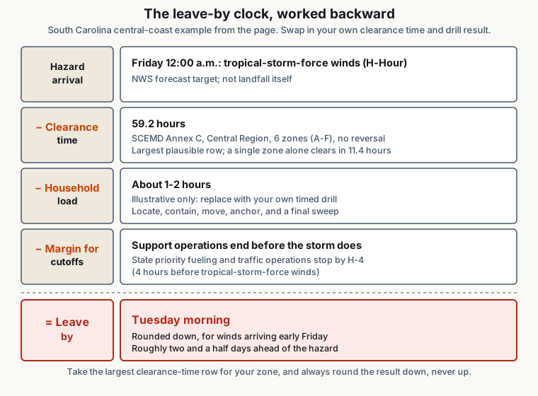
Assume a household on the South Carolina central coast, in an evacuation zone, with two dogs, two cats and a bearded dragon, planning against tropical-storm-force winds forecast to arrive at 12:00 a.m. Friday.
| Term | Value used | Where it comes from |
|---|---|---|
| Hazard arrival (H-Hour) | 12:00 a.m. Friday | NHC forecast for arrival of tropical-storm-force winds |
| Clearance time for the zone combination in the order | 59.2 hours, the largest plausible row for the region rather than the smallest | SCEMD Annex C, May 2026; Central Region rows span 11.4 hours for one zone to 59.2 hours for six with no reversal |
| Support cutoffs to stay ahead of | Priority fueling ends no later than H-4; state traffic operations demobilize H-4 to H-0 | SCEMD Annex F and Annex A, 2026 editions, South Carolina only |
| Household load time | Your drill result. Say it comes back at 70 minutes with two adults home, and 2 hours 15 minutes with one. | Your own timed drill, not a published figure |
| Reptile container preparation | Finished before the general load starts, not during it | Treated as a preceding block |
- Fix H-Hour, not landfall. Both the state’s cutoffs and NHC’s preparation warning are keyed to arrival of 39 mph sustained winds.
- Subtract the clearance time for the largest zone combination that plausibly includes you. In the example rows, that is the difference between planning against 11.4 hours and 59.2. Choosing the small one is the most expensive assumption on this page.
- Subtract your household load time, using the one-adult version if a weekday order is realistic. Subtract all of it, not a residual, since the overlap with the unpublished mobilization allowance moves the answer earlier.
- Subtract a margin for the cutoffs. If state priority fueling ends at H-4, being on the road looking for a pump near that hour is planning to fail.
- Check the single-egress override. If a crossing closure threshold lands earlier than everything above, that is your leave-by time.
- Round down, never up.
Now land it. H-Hour is 12:00 a.m. Friday. Subtract 59.2 hours and you are at 12:48 p.m. Tuesday. Subtract the illustrative 70-minute load and you are at 11:38 a.m. Tuesday. With the one-adult figure of 2 hours 15 minutes you are at 10:33 a.m. Tuesday. Rounded down, the answer is Tuesday morning for winds arriving early Friday.
Three notes. The H-4 fuel cutoff does not bind at a Tuesday-morning departure; leave that early and the support cutoffs stop being your problem, whereas they become the whole problem for a household leaving Thursday. The only invented figure is the load time. And the load subtraction knowingly overlaps the mobilization allowance inside the 59.2 hours, which moves the answer earlier.
The obvious objection. Tuesday morning is roughly two and a half days before the winds, when the NHC cone may still be too wide to show your county clearly inside it. That is why clearance times are published: a six-zone evacuation takes longer than a forecast is precise, so the decision is made under uncertainty by design. Treat the first pass as a provisional date, re-run it at each advisory as the cone narrows, and move the date later only if the forecast genuinely moves, never because the drive looks easy.
The output is a date and a rough time of day, which is the resolution the decision needs, and it will usually land earlier than the evacuation order for your zone. The road network was planned around people who leave before they are told to.
What to Do This Week
- Look up your evacuation zone with your county emergency management office and write it down where you can find it without a search.
- Find and save your clearance-time document. Save the largest row that could apply to you.
- Find your single-egress threshold, if you have one, from the authority that operates the crossing. It overrides everything else.
- Time your load. Run the drill, write the result down, and run it once more with one fewer adult than usual.
- Confirm a destination independent of the shelter list. The general shelter list may not settle until about a day before an evacuation starts, per South Carolina’s mass-care annex, and Annex G carries no pet or animal content. SCEMD’s pet planning page says:
“Most emergency shelters will not accept pets (with the exception of service animals) due to health reasons”
It adds that some counties plan temporary emergency animal shelters, but not all are in place, and they should be used only as a last resort. A confirmed hotel or a relative’s house is a destination; a hope is not.
- Check the currency of everything you saved at the start of each season. A June 2026 state DOT document carries superseded alert lead times, and a county explainer rests on 2010 Census data. Documents drift, and the fix is a calendar reminder.
Where to Go Next
- Hurricane pet preparedness playbook for the watch-to-warning preparation sequence.
- Bridge and causeway closure thresholds for the single-egress override.
- The T-minus storm countdown card for turning the date this page produces into an hour-by-hour sequence.
- Pet fire evacuation drill checklist to produce the household load number.
- Evacuation traffic gridlock with pets for when timing fails and the vehicle stops moving.
- Loading carriers for multiple pets for the restraint and anchoring method.
- Horse and livestock evacuation basics for the earlier, hazard-branched clock that governs a mixed property.
- Multi-pet emergency planning for households where animal count is the constraint.
- Pet emergency playbooks for the hazard-by-hazard library.
Every timing figure above is attributed to the agency that published it and scoped to its jurisdiction. Evacuation orders, clearance times, contraflow rules and shelter policies are set locally and change between seasons. Get your own numbers from your county emergency management office, your state DOT and the National Weather Service before you rely on them.
Frequently asked questions
How early should I leave with pets during a hurricane?
Do a subtraction for your own county. Start with the hour tropical-storm-force winds are forecast to reach you, subtract your zone's published clearance time, and subtract the time your household needs to locate, crate, load and drive. South Carolina's Annex C models a six-zone Central Region evacuation at 59.2 hours. Lee County, Florida's explainer says an out-of-county evacuation would begin 89 hours before storm-force winds, but that page dates to 2015, so confirm with the county.
Does a Hurricane Watch mean it is time to leave with my pets?
No. A Hurricane Watch is a forecast product, issued 48 hours before tropical-storm-force winds are anticipated. A Hurricane Warning comes 36 hours before. The instruction to leave comes from local officials as an evacuation order for your zone, and where clearance takes longer than 36 hours that order can come before the warning. Treat the watch as the point when animals, carriers and documents should already be staged.
Will contraflow or lane reversal buy me extra time to load my pets?
Plan as if it will not. FHWA's June 2021 review calls contraflow in most cases a last resort, and Texas DOT told FHWA it takes at least 36 hours to implement fully. South Carolina's modelling shows a modest gain: 59.2 hours without the I-26 reversal, 54.8 with it. Georgia times its I-16 decision to clearance times. That is capacity management on the state's clock, not extra minutes on yours.
Can I use the shoulder in Florida if I am towing a trailer with my animals?
No. FDOT says that when Emergency Shoulder Use is operational, all motorists except large trucks, buses and trailers may use the shoulder as a travel lane. ESU replaced Florida's former contraflow plans. If you tow crates or livestock, budget travel time against normal lanes only. Other states run different programs, so check the DOT that operates your corridor.
How much time should I budget for catching and crating my pets?
Measure it. The federal and state guidance we reviewed covers what to prepare and when agencies act, but leaves per-animal capture and loading time to the household, since it depends on your animals, floor plan and helpers. Ready.gov's advice to note where pets hide is the closest acknowledgement that finding an animal is its own task. Run a timed drill and treat the result as a fixed cost.
What about wildfire, where there is no forecast lead time?
The subtraction does not work, because the first term is unknown until it is very small. NIST's study of the 2018 Camp Fire found routes that took 25 minutes in normal traffic took several hours, if passable at all, for roughly 40,000 evacuees. Move the household load off the day of the fire: stage carriers, documents and a destination, and get animals used to the box.
Free checklist
Get the printable pet go-bag checklist by email
A one-page, print-ready go-bag checklist grouped by Ready.gov, ASPCA, AVMA, CDC and Red Cross categories, with a link to the full guide for per-animal quantities. One email to confirm it's you, then the checklist, the binder templates and occasional new guides. Unsubscribe any time.
Sources
We are not veterinarians, and we would rather you check these than take our word for anything. These are the sources this page relies on. For your own animal, your vet is the expert, not this page.
- NOAA National Weather Service: Hurricane and Tropical Storm Watches, Warnings, Advisories and Outlooks (watch/warning and storm surge lead times; Extreme Wind Warning) (opens in a new tab)
- NOAA National Hurricane Center: Changes to Tropical Cyclone Watch and Warning Lead Times (the 12-hour increase effective with the 2010 season, and the stated reason) (opens in a new tab)
- NOAA National Hurricane Center: Glossary of NHC Terms (watch, warning and storm surge definitions) (opens in a new tab)
- NOAA National Hurricane Center: Atlantic Tropical Weather Outlook (live conditions) (opens in a new tab)
- South Carolina Emergency Management Division: Annex A to the Hurricane Plan, Evacuation Decision and Response Timelines (2026 edition) (opens in a new tab)
- South Carolina Emergency Management Division: Annex C to the Hurricane Plan, Evacuation Zones and Clearance Times (May 2026 edition; tables reflect the 2024 HES clearance time update and 2023 ESRI Business Analyst population estimates) (opens in a new tab)
- South Carolina Emergency Management Division: Annex E to the Hurricane Plan, Traffic Management (May 2026 edition) (opens in a new tab)
- South Carolina Emergency Management Division: Annex F to the Hurricane Plan, Hurricane Evacuation Fueling and Refueling Operations (May 2026 edition) (opens in a new tab)
- South Carolina Emergency Management Division: Annex G to the Hurricane Plan, Hurricane Response Shelter Management (May 2026 edition) (opens in a new tab)
- South Carolina Emergency Management Division: Hurricane Traffic Management (when evacuation operations stop) (opens in a new tab)
- South Carolina Emergency Management Division: Pet Planning (state guidance on shelters and pets) (opens in a new tab)
- Federal Highway Administration, Office of Operations: Disaster Recovery Reform Act Section 1209 (Contraflow Provision): State of the Practice in Selected Locations, June 2021 (opens in a new tab)
- Florida Department of Transportation: Emergency Shoulder Use (ESU); routes last updated 2025 (opens in a new tab)
- Georgia Department of Transportation: Hurricane Safety & Evacuation Routes in Georgia (opens in a new tab)
- Georgia Department of Transportation: Hurricane Guidelines, released June 15, 2026 (copy hosted by Chatham County CEMA) (opens in a new tab)
- Lee County (Florida) Emergency Management: Evacuation Clearance Times for Lee County Explained (page dates to 2015; resident counts cite 2010 Census and GIS data) (opens in a new tab)
- Ready.gov: Prepare Your Pets for Disasters (last updated March 20, 2026) (opens in a new tab)
- Ready.gov: Evacuation (last updated March 20, 2026) (opens in a new tab)
- Ready.gov: Wildfires (last updated May 11, 2026) (opens in a new tab)
- AVMA: Pets and Disasters (opens in a new tab)
- NOAA National Weather Service: Tsunami Safety, During a Tsunami (opens in a new tab)
- NIST: Life Safety During the Camp Fire (findings from NIST Technical Note 2252, A Case Study of the Camp Fire, Notification, Evacuation, Traffic, and Temporary Refuge Areas) (opens in a new tab)